My 1983 Appalachian Trail Hike in Photos
I wrote a ton in words in my journal as I hiked the Appalachian Trail. I also shot a ton of Kodachrome slides in that pre-digital age. I've scanned all my old AT slides and posted them with short text blurbs connecting them to their parts of the story. I'd never tried to connect all these slides with all these words before. It helped me remember details of that long-ago hike in new ways. These pages are a chronological visual journal of the hike. Probably one of the oldest thru-hikes on the Internet to get one.
More pics from my 1983 Appalachian Trail hike. Table of Contents is here.
Whitetop Laurel Creek Gorge, VA - Pine Mountain, VA

Still in Chapter 7 of my Appalachian Trail book. Late afternoon on June 9, 1983, I began a long climb up Whitetop, the second-tallest mountain in Virginia.
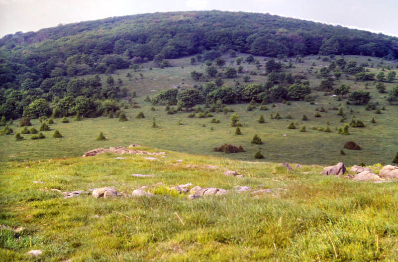
Extensive meadows covered the crest near the summit. I trod open grasslands beneath a hazy, whitewashed sky and felt my flagging spirits revive a little. It was a great place for me to be at that moment.


Ahead lay Mount Rogers, the tallest mountain in Virginia, and more vast expanses of grassy, open ridge crest. That was a climb and ridge walk for tomorrow.
I had the first rattlesnake encounter of my hike while walking down into the gap between Whitetop Mountain and Mount Rogers. At the end of an exhausting and eventful day, I made a bigger impression on him than he on me.
I spent the night in Deep Gap Shelter on a forested slope of Mount Rogers. I had the place all to myself, which gave me plenty of time to miss friends both old and new. I was 935 AT miles from my home state Connecticut, as I lay there that night in southwestern Virginia.
Still June 9, 1983, and Chapter 7 of my story.

The next morning, June 10, 1983, brought even nicer weather than the previous day. I spent the day under a deep blue sky wandering a high green country of forest and rocky pastures encompassing Mount Rogers and its surroundings.
I was all over the place June 10 on side trails exploring the magnificent Virginia Highlands. These were among the last truly spectacular mountains over which the AT passed before reaching New England.


The AT further north in Virginia along the Blue Ridge and through Shenandoah parallels the Blue Ridge Parkway and Skyline Drive, which diminishes the hiking experience. Many stretches approach spectacular, but there's nothing like this.
Mount Rogers, the highest mountain in Virginia, dominated the morning views.
Still June 10, 1983. Still Chapter 7.


My first side trip of the day began less than a mile from the shelter. The Appalachian Trail began following a long fence line, on the other side of which a sprawling, grassy field slanted far down the mountainside.
The fence and the field were also on National Forest land. The United States Forest Service allows farmers to graze cattle in these fields in the summertime in order to prevent them from becoming overgrown.


I spent the best part of an hour wandering off the trail all over that field taking photographs and enjoying the Views.
Still June 10, 1983. Still Chapter 7.
Green farming valleys carved an intricate web through mountains and foothills stretching out into the distance with Whitetop, Mount Rogers, Wilburne Ridge, and all of the surrounding peaks rising in the foreground.


Unlike the Roan Highlands, the open fields throughout the Mount Rogers area did not seem to be natural balds. In places which hadn't been grazed recently, thick scrub covered the landscape.
A little while later, I took a one-mile round trip from the AT simply to stand upon the summit of the highest mountain in Virginia and experience its beautiful spruce and fir forest.
Still June 10, 1983. Still Chapter 7.


The peak had no views, but I spent ten minutes savoring the sights and sweet aroma of a very New England-like forest and feeling just a little bit homesick. Then back to the open grasslands.
Still June 10, 1983, and Chapter 7 of my story.
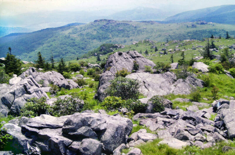
I took a side trail to the top of a small, rocky outcrop in Rhododendron Gap. I finished off the roll of film in my camera and put a new one in before moving on.


A bit later I decided to tackle the Wilburne Ridge Trail rather than staying on the Appalachian Trail.
This path was longer and considerably more difficult than the AT, but much more scenic. It followed the ridge crest over several rocky, grassy summits which the AT merely skirted.
Still June 10, 1983, and Chapter 7.


I was about a mile down that trail when I realized that my exposed roll of film was still sitting on that outcrop in Rhododendron Gap. The trip back and forth to retrieve it added two more unofficial miles to my day.
While I was back at the outcrop, I took another pic so that I'd have something to show for that two-mile round trip in addition to the forgotten roll of film now safely stored in my backpack.


You've probably noticed, but in addition to the scrub growth, another big difference between the Mount Rogers area and the Roan Highlands was the rocks. There were some rocks in the Highlands, particularly on and around Hump Mountain, but nothing like the outcrops here.
With all the side excursions, I was not making good time as far as Appalachian Trail "book miles" today.
Still June 10, 1983. Still Chapter 7.


Anyway, some days just demanded extra time and extra off-the-AT miles. I couldn't always oblige that feeling and still finish the Appalachian Trail, but I'm very glad I did here.
There was something about Mount Rogers and the surrounding highlands to me that resembled western landscapes.


Perhaps the people who conceived letting small herds of horses wander these hills in a semi-wild state also felt this.
Still June 10, 1983. Still Chapter 7.
Still June 10, 1983, and Chapter 7 of my story. Still hiking the Mount Rogers / Grayson Highlands section of the Appalachian Trail.


The Appalachian Trail wandered an incredibly circuitous course from Rhododendron Gap, where I left my film, to Pine Mountain. The old AT, now a blue-blazed side trail, once connected the two points with two easy miles of level ridge walk. Then the state decided to build a skyline drive over that route.
The current trail meandered a leisurely eight miles, drifting across a green and constantly changing landscape.
Still June 10, 1983. Still Chapter 7.


I have since heard that the proposed road project has never been completed, but the AT still follows the new route.
A lot of hikers used the old AT route to cut off the extra mileage, but I welcomed the chance to savor the Grayson Highlands.


The character of this hike would be changing now. The ridges between here and New England would, for the most part, lack the height and spectacle of the misty giants I had been traversing.
Still June 10, 1983. Still Chapter 7.
That would mean less climbing, somewhat gentler terrain, and a chance to make up the time I lost while whipping myself into shape early on.

Road crossings and supply points would also be more frequent.
On the other hand, I would be losing the frequent rewards of panoramic vistas and would have to find something inside myself to replace the bursts of adrenaline they provided, which so often kept me going when I was wearing down.
My hike would become a more introverted experience. It was June 10, and summer was advancing inexorably upon these mountains. There would be many more travails and obstacles to challenge my dream over the long, hot summer to come.
Still Chapter 7 of my story.


Later, as I descended along the ridge, I encountered a herd of about fifteen wild horses grazing a grassy saddle between two rocky knobs. I took a couple of long-range shots with my camera as I advanced carefully towards them.
Just as I was coming into position for some good close-ups, a group of riders on horseback lumbered by and chased them off.


The Wilburne Ridge Trail merged back into the AT, which soon crossed a lofty grassland plateau in Grayson Highlands State Park.
Still June 10, 1983. Still Chapter 7.
There again, I came upon the wild horses. One more time, I moved in for close-ups, but that same group of riders again showed up at the critical moment and chased them off.


With the sincere desire never to have to see those people again, I sat down for five minutes in order to let them get far ahead. Checking my watch and guidebook, I discovered that all of my side trips had caused me to travel less than five book miles of the Appalachian Trail in five hours. That was okay, because no more excursions were planned for today.
Stopping was a good move, because the horses returned almost as soon as the riders disappeared over the horizon.
Still June 10, 1983. Still Chapter 7.


I approached to within fifty feet while they stared at me calmly and munched grass. They seemed to harbor no apprehensions about a man on foot.
Nevertheless, I quickly moved on. I felt they had been disturbed enough for one day, particularly since several young foals were with the herd.


From that highland plateau where I finally walked among the horses, the Appalachian Trail headed eastward, clawing up a cliff face to a rocky outcrop.
Still June 10, 1983. Still Chapter 7.
It then descended westward along those same cliffs towards the base of Wilburne Ridge in a lonely valley encircled by mountains and filled with sunny meadows and cool, dark woodlands.


Beyond the valley was a long climb up Stone Mountain, at the top of which the trail emerged onto another high, grassy plateau.
Still June 10, 1983, and Chapter 7 of my story.
There, in the fading late afternoon light, I came upon an enchanting scene, among the most memorable of this entire hike: another small herd of wild horses, grazing peacefully in a setting of apparent remote timelessness.
No fences or other works of man were visible. The mountain panorama encircling that plateau and the uncertain light both contributed a dreamlike quality to the scene.


The horses stood all around the trail, grazing on either side as I strode towards them. A foal scampered across the path, almost brushing my arm as I took several pictures at close range.
Although these gentle animals were obviously very accustomed to people, I detected a certain nervousness on their parts, again undoubtedly due to the presence of several young foals with the herd.


Not long afterwards, the AT reentered the woods and climbed Pine Mountain, rejoining the main ridge crest for some final great views from its flat, rocky, grassy summit before the endless descent.
I was leaving the Blue Ridge's western fork behind me for the last time. The next time I see the Blue Ridge, up in central Virginia, the two forks will have joined into a single range.

I'm still not done. More AT pics here.