My 1983 Appalachian Trail Hike in Photos
I wrote a ton in words in my journal as I hiked the Appalachian Trail. I also shot a ton of Kodachrome slides in that pre-digital age. I've scanned all my old AT slides and posted them with short text blurbs connecting them to their parts of the story. I'd never tried to connect all these slides with all these words before. It helped me remember details of that long-ago hike in new ways. These pages are a chronological visual journal of the hike. Probably one of the oldest thru-hikes on the Internet to get one.
More pics from my 1983 Appalachian Trail hike. Table of Contents is here.
Chairback Gap, Barren-Chairback Range, ME - Little Boardman Mountain, ME
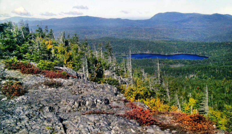
Still Chapter 24. It was a raw, bitter night, once again ending a string of warm nights after one in a row. By the time I hit the trail September 28, 1983, it was 8:30. Some things never change. The climb of Chairback was easy, and a long cliff-walk around the summit had the best views of the entire range. East Chairback Pond was a beautiful deep blue. Conditions were perfect. Apparently, a dry cold front moved through the previous night and pushed the warm, hazy air out to sea.
It was a crystal-clear, blue-sky day. Nevertheless, I could not pick out Katahdin from Chairback. The great mass of the Whitecap Range blocked most views in that direction, but a few peaks rose above the surrounding foothills. One of them must have been Katahdin, but it was not apparent to me at the time which one.


I spent a lot of time taking pictures on the mountain's summit and along some open ledges near the edge of a plateau below the cliffs. Autumn colors were finally beginning to break out in earnest. Everything about my hike seems to be timed perfectly lately.
I traversed so many mountain ranges as I followed the Appalachian Trail northeast from Georgia. Even the ones that didn't treat me so well like the Great Smoky Mountains were beautiful. Barren-Chairback was my second-to-last mountain range on the AT, so I took my time before descending from Chairback.
Still September 28, 1983. Still Chapter 24.


As the final peak of its range, Chairback Mountain had great views ahead to the Whitecap Range, my very last mountain range on the Appalachian Trail. After Whitecap, there were a handful of lower mountains scattered along the AT route, and one single lofty mountain that I had yet to catch a glimpse of and know it for sure as Katahdin. Every time I climbed a mountain purported to provide a view of that long-sought dream, either the visibility was limited, or I was just unable to pick it out from the other tiny specks on the horizon, never having seen it before.
Looking back, this was a good indication of how tired I was that morning. That large alpine summit peeking over the lower ridges just to the right of that tall tree seems hard to miss. Yet I did, for the time being.
Still September 28, 1983. Still Chapter 24.


After a short, but very steep drop down the sheer cliff face which gives Chairback Mountain its name over loose chunks of blasted shale, came an easy, more gradual descent to East Chairback Pond.
One last look ahead to the Whitecap Range, framed nicely by some extremely weather-beaten spruce.


Yet another glimpse of Katahdin before I officially saw Katahdin for the first time. Peaking over the top of that closer mountain again.
Still September 28, 1983. Still Chapter 24.
I took the side trail, such as it was, to East Chairback Pond. The path had not yet been cut or cleared, but the future route had been plotted out and marked with ribbons tied around tree trunks. It was a steep descent, and virtually a bushwhack, but the difficult access enhanced the pond’s heady aura of isolation.


As journey’s end draws near, I am filled with a growing compulsion not to miss a thing. My own personal strain of Maine Disease, I guess. I can live with it. My side trips in Maine always turn out to be worth the extra time and effort. Fifty acres of cobalt blue, East Chairback was perhaps the largest mountain pond I had encountered in Maine. Splashes of reds, golds and oranges accented the mostly coniferous forest around the shores.
Still September 28, 1983. Still Chapter 24.
At the bottom of the long descent from the Chairback range was the second-biggest water ford on the Appalachian Trail: the West Branch of the Pleasant River. Twenty-five yards across and barely knee-deep, it was no real challenge to a backpacker who had so recently waded the Kennebec. Nevertheless, a refreshing wade through icy waters always gets me humming the theme song from "The Magnificent Seven."

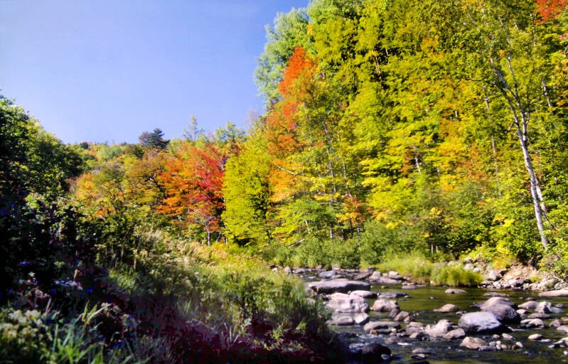
On the far side of the river, the Appalachian Trail followed an old logging track called the West Branch Road through and beyond the Hermitage -- a stately grove of soaring white pines with massive trunks surrounding a small clearing with bits of an old cabin's foundation. About a mile-and-a-quarter past the river, the AT turned off the road, which continued ahead as the start of the Gulf Hagas Trail.
I was running late again, for all of the same reasons as yesterday, but I could not pass up "the Grand Canyon of Maine." I took a one-and-a-half-mile round trip to Hammond Street Pitch: a high cliff overlooking the deepest portion of the chasm.
Still September 28, 1983. Still Chapter 24.


In those pre-digital days, I did not have the right film for the Hermitage or Gulf Hagas, so I've included a few more pics of the West Branch of the Pleasant River, where I found the amazing cool autumn forest of my sweaty summer daydreams.
It was 1:30, and I had not exactly been burning up the trail thus far. The next shelter was ten miles away. I really wanted to stay there tonight. I had heard that the location was beautiful and the structure less than two weeks old. The one small obstacle between me and some exceptional trail accommodations was the entire Whitecap Range. I needed to do some serious stepping to get there by dark.


I hiked eight miles, climbing three mountains, before stopping for my next rest break.
The initial ascent of the Whitecap Range was fairly gradual. The Appalachian Trail passed through a varied and interesting forest of hardwoods and conifers, mostly on old, abandoned tote roads. I made excellent time along this stretch.
After three-and-a-half miles, the AT crossed a stream known as Gulf Hagas Brook, wound through a bog, and leapt straight up Gulf Hagas Mountain on a very steep, rocky path. The time I had made up on the lower portion of the climb drifted away like flotsam on the tide.
The summit of Gulf Hagas Mountain was partially open.
Still September 28, 1983. Still Chapter 24.

The ridge crest appeared to have been either burned-over or clear-cut in the not-too-distant past. Covered with a low, dense tangle of scrubby growth, it sported some decent views back to the south. I paused very briefly at the summit to take it all in before turning back northward and starting down the other side. Suddenly, I was frozen in my tracks. This time it was unmistakable.
I had been zoning out at the time, moving ahead on autopilot, tuning out a snowballing mass of fatigue. I returned to the present, blinking like a man waking from a dream. Then, I saw it.
Ahead of me and to the left was a vision drawn from the mists of dreams, a legend of long-ago summer nights kept alive by the aspirations and longings of a tired wanderer.


A myth made real by the sweat and blood of two thousand weary miles. It looked so close. It was getting late. I headed down the ridge.
Beyond the summit, the crest of Gulf Hagas Mountain was a descending progression of small knobs. Viewpoints along the ridge were actually better than at the summit.
Still September 28, 1983. Still Chapter 24.
Now that I'd seen it and known it for what it was, Mount Katahdin kept popping up, over and over again.


There were other nice views as well. After days of wondering where Autumn went, I had found it.
And Katahdin kept popping up, over and over again.
It was starting to look less substantial. Although there was very little haze that day, there was some. And the sun angle was beginning to get low. Sunlight had much more atmosphere through which to pass.
Still September 28, 1983. Still Chapter 24.


And over again.
I dropped into a grassy gap between Gulf Hagas Mountain and West Peak. An official M.A.T.C. campsite was there, but it wasn't much -- just a couple of mowed patches amidst the higher scrub. A spring was supposed to be two hundred yards downhill, but I could find no marked trail. Even the Appalachian Trail was poorly-blazed and lost in a muddle of herd paths.
I lost about ten precious minutes stumbling around trying to locate the route northward. I finally found the trail and began the long, steep climb up West Peak.
Still September 28, 1983. Still Chapter 24.


This was the Katahdin of my July daydreams. I never saw myself on the mountain, just close. Looking across miles of forests decked out in reds, golds and oranges. Cool lakes reflecting the deep blue Autumn sky.
An exhausted hiker topped West Peak's summit, but I kept going and the good views gave me a bit of a lift. There were even better views along the descent into the next gap.
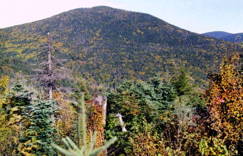
The climb up Hay Mountain was fairly reasonable, but I was absolutely spent even as I was making it. It was the third consecutive major mountain I had climbed without stopping at the tail-end of a three-day marathon. Hay Mountain was considerably wooded, but there were a few partial views near the top. I pushed on grimly, descending into the sag between Hay and Whitecap, and even managing to climb part of the steep slope on the other side.


Finally, I had to sit down for ten minutes, although the sun was setting. I ate a granola bar and drank some water. Resuming the climb, I caught an intense second wind at exactly the right moment and roared up to the summit ridge of Whitecap.
Still September 28, 1983. Still Chapter 24.
After that, it was simply a gradual ascent through dwarf spruce to the top, at which I arrived slightly before sunset.


I was just in time to experience the deep, rich colors of the sunset from a mountaintop along the Appalachian Trail for the second consecutive evening before I began the descent. I arrived at Logan Brook Lean-to at almost 7:30. Few homes had ever been such a welcome sight.
End of September 28, 1983. Still Chapter 24.

September 29, 1983. Still Chapter 24. I took my time preparing to leave the shelter that morning. I was out of my sleeping bag at 6:30, but it was 8:30 on another cool, crisp morning the second-to-the-last day of September when I took one final look at my fifth-to-the-last home on the Appalachian Trail and started hiking the remainder of that long steep slope down to the lowlands.
The AT descended moderately along the floor of the canyon for almost a mile, then slabbed the side of the slope for a brief while before dropping sharply to the foot of the mountain and crossing a gravel logging road. A two-mile stretch of nice, level terrain brought me to a fording of the East Branch of the Pleasant River. It was nothing -- my feet did not even get wet. This was followed by a steep climb up a spur of Boardman Mountain. A viewpoint at the crest looked back over the flat river valley to Whitecap, looming two thousand feet above me. I took a half-hour break, simply because it was a nice spot and I felt like it. I surrendered to Maine Disease at every opportunity, and the day drifted pleasantly. Katahdin's magnetic pull had ebbed considerably following my long-awaited first sighting the previous day.


A relatively-level ridge walk led to Mountain View Pond.
Across the small lake, Boardman Mountain's slopes were aflame with fall colors.
Still September 29, 1983. Still Chapter 24.


It looked like beavers had done some damage to some of the trees along the near shoreline.
Water and sky were an incredible blue, while conifers and late-turning hardwoods added some nice green tones to the mix. The five-month trek was climaxing nicely.
Still September 29, 1983. Still Chapter 24.


The combination of a clear haze-free sky and a rare dead calm breezeless day in northern New England at the end of September made for mesmerizing reflections of Boardman Mountain cloaked in peak autumn colors.
I probably got a bit carried away shooting pics here. But, as usual, you are free to skip ahead when you get bored.


From the pond, the Appalachian Trail climbed very gently along an old, grassy tote road before leaving the road and shooting straight up the steep slope of Little Boardman Mountain.
Still September 29, 1983. Still Chapter 24.
The AT crested the ridge at the top of some ledges with great views.


It was a perfect autumn day, the best I would get in Maine, probably the best day I got on the entire trail. The air was dry and clean with no haze or pollution. Little smoke-puff clouds stood out in 3-D against the deep blue sky, and individual trees were discernible on ridges miles away.
Still September 29, 1983. Still Chapter 24.
This was to be my third roughly nineteen-mile day in a row, although the terrain I faced this day was far less rugged than the first two, and there would be a lot less drama.


After all the angst over two thousand miles worrying about maintaining the pace I needed to reach Katahdin in about five months, I was at a place where I could coast over the next three days and climb Katahdin five months to the day I stood on Springer Mountain's summit in Georgia.
Still September 29, 1983. Still Chapter 24.
Not long before, I had been wondering if I would ever see true New England fall colors on this trip, but my final week on the trail went past in a blaze of autumnal glory.


After leaving the top of those ledges with the first great views, the Appalachian Trail continued along Little Boardman Mountain's crest and passed another ledge which had even better views.
Still September 29, 1983. Still Chapter 24.
The entire trail from the East Branch of the Pleasant to beyond this point was another 1983 relocation, for once lately one that had actually been completed before I got there. What a fantastic relocation.


Thanks to the ease of today's trail relative to the two previous days, I still had plenty of daylight with which to work, even though the mileage would be about the same.
I had a little time to burn that day, so I spent most of that time to burn on Little Boardman Mountain.
Still September 29, 1983. Still Chapter 24.

I'm still not done. More AT pics here.