My 1983 Appalachian Trail Hike in Photos
I wrote a ton in words in my journal as I hiked the Appalachian Trail. I also shot a ton of Kodachrome slides in that pre-digital age. I've scanned all my old AT slides and posted them with short text blurbs connecting them to their parts of the story. I'd never tried to connect all these slides with all these words before. It helped me remember details of that long-ago hike in new ways. These pages are a chronological visual journal of the hike. Probably one of the oldest thru-hikes on the Internet to get one.
More pics from my 1983 Appalachian Trail hike. Table of Contents is here.
Mount Kinsman, NH - Mount Jefferson, Presidential Range NH
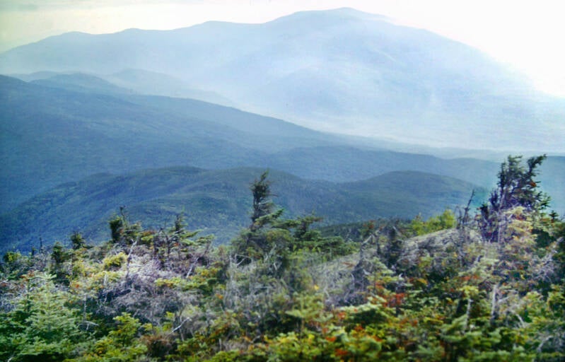
Still September 4, 1883. Still Chapter 21. The climb up the side of the peak was just as steep as the climb up to the ridge had been. It was late -- and getting later. Eventually, I broke out onto the summit area, a short stretch of alpine ridge crest consisting of gray, lichen-covered granite rock, very low scrub spruce, and ground-hugging shrubs of the type I had seen on Mount Moosilauke. There were 360-degree views, including Franconia Ridge to the east, Moosilauke and Loon Mountain to the south.
The summit was marked by a large rock cairn. Kinsman's north peak and Cannon Mountain lay to the north, west was the valley and ridge country stretching out towards the Green Mountains along the western horizon. Not far above that horizon was the rapidly sinking orb of the sun -- a pretty sight, but not too encouraging, considering the six miles I still needed to cover today.


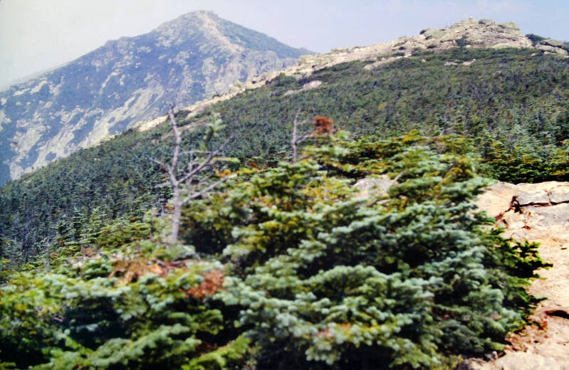
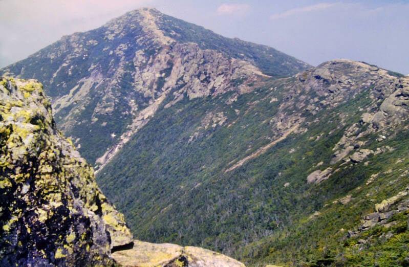
The Appalachian Trail re-entered the woods for a gradual descent into a col and a short, steep ascent of the north peak of Kinsman. It was covered with another forest of stunted spruce, but a large rock outcrop just below the summit to the east provided the best views on the mountain of Franconia Ridge with all of its spur ridges and of Franconia Notch far below. A few hundred feet below me was Kinsman Pond, another secluded mountain tarn sitting on a high plateau.
I enjoyed the views for five minutes before starting down another rocky, steep descent, along which my knees began to tell me how much they hated me, not in words, but with stabbing pains.
The trails down were similar. It was dark for most of the last few miles, but I managed to move fairly well by the light of my small pocket flashlight. I was at the AT crossing of US 3 in Franconia Notch -- almost an hour late at 8:55. End of September 4, 1883. Still Chapter 21.

September 5, 1983, Labor Day, I began hiking one of the longest stretches of the Appalachian Trail unbroken by road crossings -- the twenty-seven miles between US 3 in Franconia Notch and US 302 in Crawford Notch. I had planned to end my day hiking string here -- I was looking forward to a return to backpacking and starting hikes in the mornings. My mother really wanted to continue her first trip to the mountains, so eventually I agreed to make this section an overnight backpacking trip and meet her in Crawford Notch the afternoon of September 6.
The humidity was brutal both days, to the point where there were no views into the valleys and just dim, hazy views of other mountains along the ridge crest. I took a total of 2 pics both days combined, and they were both shot relatively early on the 5th. Both were of Franconia Ridge with Mount Lafayette looming in the hazy background. I had backpacked this entire section of the AT several times before this hike. I already had plenty of good pics.
Having started hiking my second day in the morning, I actually reached US 302 in Crawford Notch just after 2:30 in the afternoon on September 6. Still Chapter 21.

The television weather report called for high winds and heavy thunderstorms September 7, so I delayed my ascent of the Webster Cliffs Trail and the Presidential Range for one day. As an added bonus, the front cleared away the bulk of the excess humidity.
September 8, 1983 was a much better day for me and my camera. It was mostly cloudy in Crawford Notch at 12:30 when I set out on the Appalachian Trail.
A nice, stiff breeze was blowing, the air was fresh and dry, and the day was much cooler than the last few had been. As usual, that 12:30 start was considerably later than I wanted it to be.
Climbing the Webster Cliffs was not the ordeal I remembered it to be from earlier hikes.


The ascent was remarkably steep, but a great deal of excellent trail construction work had made it a much easier climb than the Liberty Springs Trail had been.
I did not take one break until I arrived at the top of the first set of cliffs, with their excellent view of the notch below. I really did not need to stop there, either, but I wanted to enjoy the spot, so I took a two-minute standing break, drank some water, ate a granola bar, and shot the pic above.
My first sit-down break was at the summit of Mount Webster. It was 2:15, and I had hiked the three most difficult miles of the day, so I sat down for ten minutes and celebrated with more water and two Pop-Tarts (yee ha).
Still September 8, 1883. Still Chapter 21.
The sky had been gradually clearing as I went along, but the clouds moved back in and then some as I climbed Mount Jackson.


From the 4052-foot summit, I could see the entire length of the trail ahead to Mount Washington. Mount Eisenhower's summit was slipping in and out of the clouds, and the top several hundred feet of Washington was completely socked in.
Looking south and west way down into Crawford Notch, where the day's trail began.
From Jackson's summit, I descended back below the trees and continued along the ridge crest to Mitzpah Spring Hut, located in a wooded col below the summit of Mount Pierce.
Still September 8, 1883. Still Chapter 21.


At the hut, I considered topping off my water bottle for the trail ahead, but a quart of water still remained. A stiff climb up Mount Pierce was on tap, so I decided not to carry the extra weight.
It was quite cool on the ridge after the heat of the past few days, and a powerful breeze was blowing. The weather sheet at Mitzpah called for fifty-mile-per-hour winds at the summits today. I could find no reason to argue with that prediction as I went along.


Like most winds, they would die down a bit to a good fresh breeze and then gust again at unpredictable intervals.
Still September 8, 1883. Still Chapter 21.
I was concentrating on making up some lost time and often distracted by the ever-changing landscape and views. My legs were soon torn and bleeding from the impact of my body being buffeted by the gale into sharp rocks and bushes adjacent to the trail.


The sun began to reemerge as I came out onto the south summit of Pierce.
Still September 8, 1883. Still Chapter 21.
By the time I made the main summit, the entire mountain basked in sunshine and the clouds had lifted from the top of Mount Eisenhower, although they hovered dramatically just above the summit.


From Pierce's 4310-foot summit, the Appalachian Trail remained above tree line for the rest of the day's hike.
Still September 8, 1883. Still Chapter 21.
I got some excellent views of the Dry River Valley and Montalban Ridge to the east, as well as the various summits and spur ridges of the Presidentials.


The light is very stark above 4000 feet. The afternoon was transitioning from cloudy to sun and clouds. Where it was in control, the sunshine was dazzling. A few darker clouds were still around, like the one over Mount Eisenhower at this moment.
Looking towards the sun could be overpowering.
Still September 8, 1883. Still Chapter 21.


I have always been slightly (and childishly) amused by the alpine summit of Mount Eisenhower's resemblance to a round bald dome.
The southern end of the Presidential Range is where the still impressive lesser peaks of the range live. Up until this point the summits I crossed had been Mount Webster (3,911 feet), Mount Jackson (4,052) and Mount Pierce (4,310). The alpine ridge crest was fairly scrubby down here, but low enough for great views.


After Pierce, Mount Eisenhower's distinctive dome begins to dominate the view north. Its 4,760-foot summit towers over the southern end of the range. The top several hundred feet of Eisenhower's dome are notably rocky and barren compared to the earlier summits.
Then I was beginning the climb of Eisenhower.
Still September 8, 1883. Still Chapter 21.


In the Presidentials, the alpine area is not confined to a narrow strip along the ridgeline. The zone of bare rock, alpine tundra and dwarf spruce often extends well down the mountainsides. Major side ridges slope down to the distant valleys west and east of the range and all of these are rocky and open as they approach the main crest, as are the headwalls of the ravines between them.
For the most part, the clouds diminished as the day went on. Between the day's low humidity and the thinner air up along the Presidential Range's ridge crest, when the sun shone it was brilliant.
Still September 8, 1883. Still Chapter 21.


Traversing Mount Eisenhower, the AT skirts the summit, avoiding the exposed crest, on which hiking is not recommended in adverse weather such as today's hazardous winds. I took the loop trail over the summit.
The wind was howling insanely as I traversed the upper reaches of Eisenhower.


But there also were the views.
Still September 8, 1883. Still Chapter 21.
This was the upper limit of the scrub spruce climbing Eisenhower from the south. The rest of the way to the summit, the vegetation was even more ground-hugging.


There was not a lot up there to block the screaming winds. The vegetation that existed up there tended to grow in small crevasses like this that had a bit of shelter. It was less effective for me.
Still September 8, 1883. Still Chapter 21.
When the trail turned smack into the wind just as I topped the summit area, my backpack turned into a sail, and I was almost blown over backwards. For a few minutes, things were fairly intense.


Fortunately, most of the ridge was partially sheltered from the full force of the blast, once I descended from the actual 4760-foot summit.
The lengthening shadows and golden late afternoon light tell a typical story from the day hiking portion of my trip. It was getting late.
Still September 8, 1883. Still Chapter 21.


Up ahead in the northern Presidentials, Adams and Jefferson were in the clear. Hopefully things would stay that way the next day when I hiked them.
For the current day's hike Mounts Franklin and Monroe looked good. The one dark cloud over the day squatted atop Mount Washington and never moved. Looked like my hike would be ending in rain... or something.
Everywhere else I looked the weather was fair, if breezy, so that was a problem for later on.


My current wind problem diminished a bit. Most of the ridge was partially sheltered from the full force of the blast, once I descended from the actual 4761-foot summit.
Still September 8, 1883. Still Chapter 21.
Looking back up towards Eisenhower's summit after the descent.


A late day glimpse of Mounts Adams and Jefferson over a broad western shoulder of Mount Washington. Heading north past Mount Eisenhauer, you get fewer looks at these northern Presidential peaks until you climb Washington. As you draw closer, Mount Washington begins to dominate the northward views.
They call these flat, "grassy" areas in the alpine region lawns, even though that golden brown stuff is not really grass.


Approaching the three summits of Mount Monroe. That's Little Monroe to the left of the main peak and Mount Franklin to its right. While Franklin was never a president, Mount Franklin is not really considered a separate mountain. Its summit, over which the Appalachian Trail went next, is only about 65 feet higher than that col ahead, so most consider it a minor peak of Monroe.
Still September 8, 1883. Still Chapter 21.
Another look at the northern Whites from the slopes of Monroe / Franklin.


Approaching the col and the summit of Mount Franklin to the right.
Those cairns — small piles of rocks — help hikers find the trail if they stray off in poor visibility situations like fog and snow squalls. Despite the relatively low heights of these cairns, they are at this point throwing off some rather long shadows. I still had to climb that big dark gray mass to the left into that slightly less dark gray mass sitting atop it.
One final look at the three peaks of Mount Monroe. Little Monroe and Monroe are actually a bit further away than they appear in the sharp, clear light of 5000 feet, a common illusion. The summit of Mount Franklin on the right was just off the AT on a very short side trail with little additional climbing.


Mount Franklin, not really a mountain yet the first 5000-foot summit of the day. The sky had cleared very nicely by the time I reached this summit.
Still September 8, 1883. Still Chapter 21.
The cloud over Mount Washington's summit loomed larger as I approached. The ridge around me began to be tinged with the golden light of the approaching sunset. This same golden light was also by now reflecting off the bottom of that cloud.


Not far past Franklin, the Appalachian Trail veered slightly right to bypass the summits of Little Monroe and Mount Monroe. It was getting very late, so I stayed on the AT as it bypassed these two peaks, which I have previously climbed. I also did not stop at Lakes of the Clouds Hut, located in the deep col between Monroe and Washington.
Still September 8, 1883. Still Chapter 21.
Mount Washington's summit resembles a huge, barren pile of loose rocks, and those rocks make the steep climb somewhat tricky and time-consuming. Slowly, I approached the sharply defined bottom border of the vast cloud as the sun, sinking low in the sky beyond distant Franconia Ridge, tinted it with gold and orange. It was like ascending into heaven. I reached the fringe of the cloud and plunged inside.


The view of distant mountains faded gradually into the golden mist, and then was gone. As I climbed, the fog thickened, and the light faded until most of it was blotted out.
I ascended through a dark, desolate landscape of black rock and dark gray cloud as a hellish wind screamed around me. It was beautiful, in a strange way, but it was a perilous beauty. I might have been on another planet.
Still September 8, 1983. Still Chapter 21.
When I broke out onto the flattish summit area at 7:00, it was a howling madhouse up there. The wind doubled. I was becoming dangerously chilled, and walking became almost impossible. I was tossed about like an old newspaper. I had to lean forward with my arms at my sides and my body extended forward with my nose barely inches above the ground in order to move forward at all into the teeth of that tempest.


I struggled towards the state-run summit house and shelter. Somehow, I made it, and caught a ride down with a supply truck. Five minutes of cloud and wind and then we were driving beneath a beautiful starry sky.
I took the last two pics of the day (this one and above) along that final ascent. The shadows from the edges of that big cloud feature prominently in both.
The previous night's weather forecast called for increasing clouds on September 9, 1983, with a chance of rain that night. Thus, as I drove to the Mount Washington Auto Road from Gorham, I was not expecting too much.
Looking down from near Washinton's summit, it's Mounts Clay, Jefferson and a shoulder of Adams.
Still Chapter 21.


What we got was one of those perfect days which are so rare in the northern Presidentials, but which, for some reason, I seem to enjoy every time I venture into these mountains.
We drove up the auto road to Mount Washington's summit.
Mounts Adams and Madison, looking across the massive valley known as The Great Gulf.
I told my mother to meet me at the road crossing in Pinkham Notch at 6:30, and she stayed at the summit house for a while to enjoy the gorgeous day.
I started hiking at 12:15. I climbed over the actual 6288-foot summit of the tallest mountain in New England and started down the other side.
Still September 9, 1983. Still Chapter 21.


The previous times I hiked the Presidentials, the Appalachian Trail did not traverse Washington's summit. Thanks to a short connecting trail which links the old side trail to the summit with the Gulfside Trail, it is now officially part of the AT.
The base of the Great Gulf spilling out into Pinkham Notch. New Hampshire Highway 16 is plainly visible snaking through the notch.
Looking down from Mount Washington into Tuckerman Ravine. The small dark blue blob is called Hermit Lake.
There is a stark beauty to mountains such as these which cannot be found anywhere else. Even the quality of the light itself is different. At that altitude, the air is cleaner and thinner. Thus, light is considerably less diffused than in the lower world. Everything looks sharp and clean, with sharply defined shadows and strong light-and-dark contrasts.
Still September 9, 1983. Still Chapter 21.


I had intended to stay on the AT and bypass the summit loops over Mounts Clay and Jefferson, which I had previously hiked, and take the summit loops over Mount Adams and Mount Madison, the only two Presidentials which I had never climbed.
However, the day was so perfect that I had to hike the Mount Clay loop for the best views on the range of the Great Gulf, a vast semicircular glacier carved valley nestled in the long curve of the northern Presidentials.
Still September 9, 1983. Still Chapter 21.


I did take the Appalachian Trail around the summit of Mount Jefferson. After all, the forecast was calling for increasing clouds. I had a weird track record hiking the northern Presidentials in the past. Each time I did, I received uncharacteristically beautiful days like this day to enjoy Mounts Washington, Clay and Jefferson. But then each time, later in the day the weather would begin to turn, and I had to bypass Mount Adams. I would stay in Madison Hut that night. The next day was always rainy with low ceilings, so I would skip Mount Madison.
This time I would stay on the Appalachian Trail as it bypassed Jefferson, a summit I had been on several times, and make sure to take the summit loops over Adams and Madison.
Adams is a massive and impressive mountain, one of the highlights of the entire Appalachian Trail.
Still September 9, 1983. Still Chapter 21.
I'm still not done. More AT pics here.