My 1983 Appalachian Trail Hike in Photos
I wrote a ton in words in my journal as I hiked the Appalachian Trail. I also shot a ton of Kodachrome slides in that pre-digital age. I've scanned all my old AT slides and posted them with short text blurbs connecting them to their parts of the story. I'd never tried to connect all these slides with all these words before. It helped me remember details of that long-ago hike in new ways. These pages are a chronological visual journal of the hike. Probably one of the oldest thru-hikes on the Internet to get one.
More pics from my 1983 Appalachian Trail hike. Table of Contents is here.
Little Boardman Mountain, ME - Three Rainbow Deadwaters, ME

Still September 29, 1983. Still Chapter 24.
A ledge along the ridge crest of Little Boardman Mountain on a perfect autumn day at the end of September had provided the best perspective yet of miles upon miles of oranges, reds and golds mixed in with the greens of spruce and fir.
Eventually I had to get going. The trail dropped off of the little ridge and returned to the true lowlands.


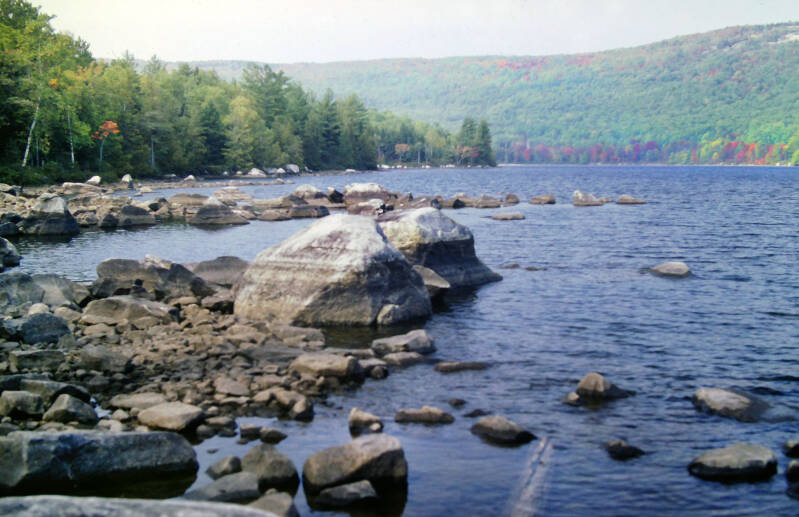
The Appalachian Trail skirted one of the many large lakes for which this portion of Maine is famous. This one was called Crawford Lake. There were views back across the lake to Little Boardman Mountain and a number of other low ridges.
Five or six fishermen were out on the water in small boats -- quite a few people to see all at once in this remote part of Maine.
Still September 29, 1983. Still Chapter 24.


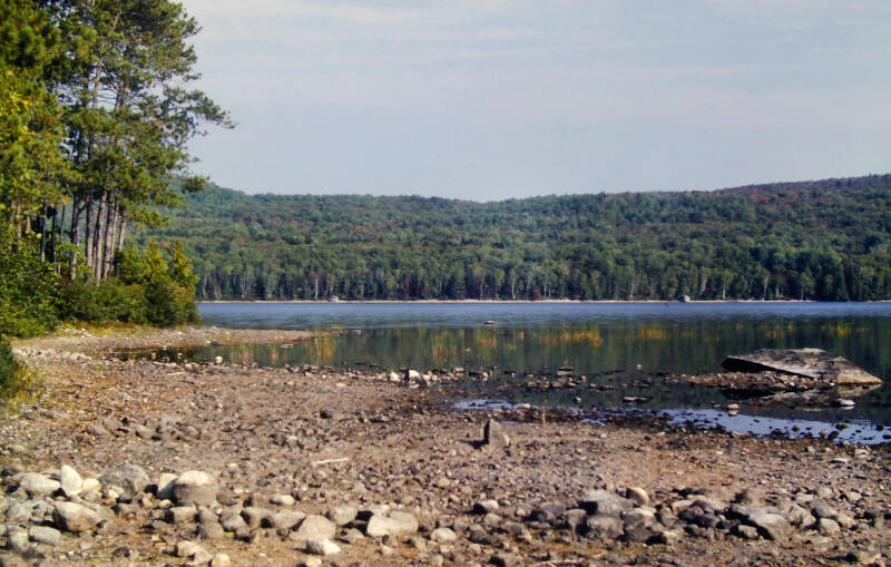
The Appalachian Trail followed the rocky south shore of Crawford Lake for about a mile.
Most of those rocks along the shore normally were part of the lakebed. The long, hot, dry summer had lowered the water levels of all these lakes and ponds considerably.


Both this stretch of rocky shore and the scraggly, unusual plants growing out of it were also usually underwater.
Still September 29, 1983. Still Chapter 24.
After crossing Cooper Brook, the lake's outlet stream, the Appalachian Trail turned away from
Crawford Lake. Once I left the lake behind, the character of the trail changed.
The Appalachian Trail trod old, abandoned tote roads along the course of Cooper Brook for eight miles, usually out of sight of the stream. The forest was rather attractive, but this stretch was fairly dull compared to the preceding trail.


I made my best time of the day along it. I passed Cooper Brook Lean-to, which sat beside an attractive cascade, and I brushed against the shores of several ponds. There was no third consecutive night hike at the end of this day, but I did not miss it by much.
Still September 29, 1983. Still Chapter 24.
At 6:20, the Appalachian Trail passed a small peninsula thrust into an enormous expanse of water. Along the eastern edge, a string of about a dozen aging wooden cabins slumbered beneath giant pines of even greater antiquity along a gravel shore. When I took breakfast at Carrying Place Camps near Pierce Pond, on the morning I would ford the Kennebec, I mentioned they were the first of three sets of old hunting camps still on the AT. This was the second: Old Antlers Camps on Lower Jo-Mary Lake.

Unlike Carrying Place, these cabins were long ago abandoned to the forest. Most were ruined shells, gradually crumbling through slow years of neglect. However, two were still habitable. Near the point of the peninsula, cabins #1 and #3 had been rescued from decay. Two men were set up in #1 when I arrived, but #3 was empty. That was my new home for the night.
End of September 29, 1983. Still Chapter 24.
Still Chapter 24. The morning of September 30, 1983, I faced a decision which had been postponed since Monson. I had a choice of taking two more long days or three short ones to reach Baxter State Park and its campgrounds at the foot of Katahdin. I chose to spend the entire morning of the last day of September savoring old Antlers Camps. It was a relaxing and soul-restoring interlude.
The previous night after dinner, I lay back on my bunk and listened to the cries of the loons floating over the lake, accompanied by the mournful song of a lone coyote drifting down from the hills. The magic I discovered on a similar night at Pierce Pond returned to me, and I grew to love old Antlers. I just lay in bed for a half-hour after awakening the last morning of September. Loons were still calling, and the rising sun was creating long undulating ripples of gold upon the gently lapping waters of the lake beyond my screen door. Why get up?
Many of you are probably too young to remember when taking a selfie involved finding a convenient place like a flat rock to set your camera down on, start the eight-second self-timer, and run like hell to dive onto a bench in time to pretend you're just chillin' when the shutter releases.
Note: Some years ago, I learned that the cabins had been removed after a fire.


The other two guys who spent the night at Old Antlers left early, and I had the whole place to myself. I whiled away the morning sitting beside a wooden table on the front porch of #1, relaxing and enjoying a show. Loons were swimming and diving for fish out upon the lake. The tall pines were teeming with songbirds.
Red squirrels were gathering up fallen pinecones, then racing high up into the treetops, dropping cones to the rocks below. The shells smashed and the squirrels would come tearing back down, dashing around like maniacs, gathering up the meat. Stuffing their cheeks, they sprinted back to their nests. They grew bolder about my presence as the morning progressed. One ran past not three feet from my toes.
Still September 30, 1983. Still Chapter 24.
I left Old Antlers at noon. I wished I had enough food for a fourth night on the trail -- I might have spent it right there, although Katahdin was calling.
The first one-and-a-half miles of trail lingered near the shoreline of Lower Jo-Mary Lake. It was a pleasant walk, and the going was easy. I could see the deep blue waters of the lake through the trees as I walked. Often the trail touched the rocky shoreline.
It was hazy and humid, and the temperature must have climbed into the seventies. I had worked up a fairly impressive sweat. 1983 had been a strange year for weather, and I had been right out here in the middle of it all. They tell me that it generally rained two out of every three days up there that time of year, and yet I had seen only two partial days of rain throughout the entire state. Now, I enjoyed a summer-like day in northern Maine on the last day in September.


Just before the trail turned away from the lake, I passed a lovely little beach of soft sand. The afternoon was almost warm enough for a swim.
The trail made a nothing climb over Potaywadjo Ridge and descended to Potaywadjo Spring Lean-to.
Still September 30, 1983. Still Chapter 24.
I sat there for an hour, leisurely flipping through the register and sampling the finest water on the Appalachian Trail. The spring bubbled out of the ground six yards in diameter, and it was cold and delicious.
After the shelter, the AT descended for a half-mile to Pemadumcook Lake, which was even bigger than Lower Jo-Mary.


Its shoreline was even rockier than Lower Jo-Mary's had been. Along this shore, I almost bumped heads with my fourth moose on this hike, a female.
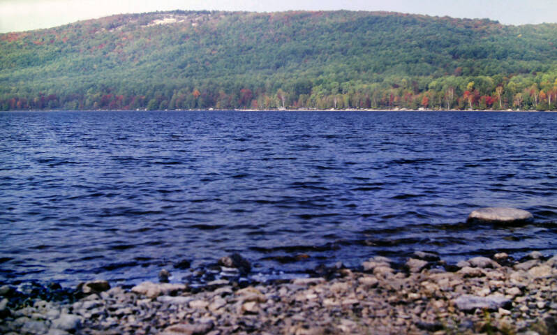
A short side trail led to a point along the shore with an awesome view of Katahdin across the lake, but only the dimmest outline of the mountain was visible through the haze. It looked so close, but it still seemed like a dream.
if you look carefully, towards the right of this pic, just above that nearby ridge, you can see that ghostly outline of Katahdin.
Still September 30, 1983. Still Chapter 24.


In this cove, a large tree had grown, a good distance from the edge of the forest. Then it had fallen, leaving just a bleached stump. It looked deader than dead, but a new green shoot was sprouting from the center of the stump. This would be the perfect spot for a cheesy metaphor, but I just thought it looked cool.
After Pemadumcook Lake, the Appalachian Trail crossed a logging road and followed Nahmakanta Stream for five miles.


The stream was wide and scenic, presenting numerous different faces to me as I followed its meandering course.
Still September 30, 1983. Still Chapter 24.
There were swift little cascades, slow-moving stretches over gravel bars, and placid deadwaters. The birch trees along the banks were bursting into their autumn fires and the spruce smelled wonderful.


After five miles, I was finally beginning to tire of following the stream. The AT came out onto a beach on the lower end of Nahmakanta Lake.
Still September 30, 1983. Still Chapter 24.
I filled my water bag at a small spring near the shore. I was a half-mile from Wadleigh Spring Lean-to, and I had read in the last shelter's register that its spring had dried up.


I ended my 13.5-mile half day at that shelter.
End of September 30, 1983. Still Chapter 24.
October 1, 1983. Still Chapter 24.
The first day of October in the North Maine Woods was a warm one -- even warmer than yesterday. It was not even a bit chilly when I awoke. I climbed my second-to-the-last mountain on the Appalachian Trail.
The initial two miles were a climb to the north summit of Nesuntabunt Mountain. The name was bigger than the mountain, but it was still a hell of a little climb. The trail was steep, and the footway was terrible. In the warm, humid air, I was soaked with sweat by the time I reached the summit.
I had spent a lot of time worrying as I walked myself into shape about the possibility of not reaching Katahdin before the first snowfall.


That possibility seemed quite remote on a day like this with the sticky air misting the cool surface of the lake below two days out from the end of the trail.
The trail today was fairly rugged for this flat lake country.
Still October 1, 1983. Still Chapter 24.
A short side trail led to an impressive view of the lake below and Katahdin up ahead. The guidebook said Baxter Peak was sixteen air miles away, although I still had thirty-four to walk. The haze had thinned somewhat since yesterday, and Katahdin looked a bit more substantial. Thanks to water's natural light polarizing effect, the reflection of Katahdin on the calm surface of Nahmakanta Lake looked even more substantial than the real thing above.


After descending, the Appalachian Trail passed a small, wild beaver pond and continued ahead to some low bluffs overlooking Pollywog Gorge.
Still October 1, 1983. Still Chapter 24.
My favorite portion of the day was the half-mile that the AT wound along the bank of Pollywog Stream.


It was a cheerful little stream, and the fall colors were the best I had yet seen.
This would have been a great day weatherwise to have climbed Katahdin. I could only hope the day after tomorrow would come close to this.
Still October 1, 1983. Still Chapter 24.


After crossing Pollywog Stream on a logging road bridge, the AT proceeded to Rainbow Stream. Despite its name Rainbow Stream had a little less color along its banks than Pollywog Stream that day -- but just a little less.
The Appalachian Trail followed Rainbow Stream upstream for a good distance, passing a long series of cascades and small waterfalls.
Still October 1, 1983. Still Chapter 24.


After two miles, I reached Rainbow Stream Lean-to, where I took my first real break of the day.
I had eight miles under my belt and had climbed that second-to-the-last mountain on the Appalachian Trail. I kicked back with the register for a half-hour.
Still October 1, 1983. Still Chapter 24.


When I set out again, I crossed Rainbow Stream and followed the opposite bank past the three Rainbow Deadwaters.
These were small pond-like stretches, along which the stream widened, and the current became very still. The scenic qualities of the lake country continued to be a pleasant surprise.
Still October 1, 1983. Still Chapter 24.

I'm still not done. More AT pics here.