My 1983 Appalachian Trail Hike in Photos
I wrote a ton in words in my journal as I hiked the Appalachian Trail. I also shot a ton of Kodachrome slides in that pre-digital age. I've scanned all my old AT slides and posted them with short text blurbs connecting them to their parts of the story. I'd never tried to connect all these slides with all these words before. It helped me remember details of that long-ago hike in new ways. These pages are a chronological visual journal of the hike. Probably one of the oldest thru-hikes on the Internet to get one.
More pics from my 1983 Appalachian Trail hike. Table of Contents is here.
Dream Lake, Mahoosuc Range, NH - Baldpate Mountain, ME

Highlights were piling up on top of each other so fast it was almost an overload to the senses. Dream Lake seemed like just another in a long series of lovely, wild beaver ponds high atop the ridge crest. On a whim, I detoured a short distance on the Peabody Brook Trail along the pond's northeast and east shores.
Thanks to my hunch, I was treated to a memorable scene -- a beautiful mountain tarn cradled by a semicircle of low ridges. A small, triangular gap directly behind the pond framed a perfect picture of a cloud-shrouded Mount Madison apparently hovering above the lake, mirrored in the lightly rippling, crystal clear waters.


Figuring there should probably be some good views near that open area at the opposite end of the pond, I continued around. As I hoped, I came upon some more open ledges.
There to the southeast was that lake created by a dammed Androscoggin River with the set of railroad tracks cutting across the middle of the pond.
Once again, the sun was shining on the Carter-Moriah-Wildcat Range beyond the Androscoggin. Timing is everything.
Still September 13, 1983. Still Chapter 22.
I had similar great views southward to those I had just enjoyed from Wocket Ledge. Clouds wreathed the peaks of Madison and Adams, dumping God-knows-what all over those backpackers brave enough and foolish enough to be taking on the northern Presidentials today.


The Presidentials are lofty enough to create their own weather, especially Mount Washington, where wind currents sweeping up the mountain a few days earlier created a sort of stationary low-pressure system right at the mountaintop with thick clouds and howling winds.
Looking west and southwest over the southern Mahoosuc summits I had hiked the previous day.
It was still all clear everywhere else in my field of vision -- a broad sweep of ridges and valleys.
Still September 13, 1983. Still Chapter 22.


It was tough to leave, but I still had to walk back to the other side of Dream Lake just to rejoin the Appalachian Trail and resume today's hike. This had all been a long, pleasant intermission.
After I rejoined the Appalachian Trail, it climbed slightly back to the ridgeline and followed it for a while past yet another scenic little beaver pond, Moss Pond, just below the ridge crest.


The Appalachian Trail then descended alongside Moss Pond's outlet brook to Gentian Pond, where a trail shelter perched atop a small ridge which was flanked by the pond on one side and another great view to the south on the other. I caught up to a couple of guys there -- the first people I had encountered since leaving Gorham. They had camped beside Dream Lake the night before.
Still September 13, 1983. Still Chapter 22.
Success in climbing Mount Success was rewarded with about a quarter mile of open ridge walk and constant 360-degree views.


It wasn't easy to get here. Past the shelter, the Appalachian Trail assumed the level of difficulty which I had expected to find in the Mahoosucs. A near-vertical ascent of smooth rock ledges was followed by an abrupt plunge into a col. I struggled over a couple of rugged knobs and commenced a long, grueling climb up Mount Success.
The air remained chilly, but I was sweating up a storm. The footway was a twisted mass of loose rocks and tree roots, topsoil eroded away down to the bedrock. But the views at the top made it all worthwhile.
Still September 13, 1983. Still Chapter 22.


Looking north at the mountains still to come.
The trees that did manage to grow near the summit ridge showed signs of the struggle.


Looking west to the Androscoggin River valley and Berlin, the northernmost city in New Hampshire. Yes, I was looking southeast at this river valley earlier. Coming down from the north, the Androscoggin bends eastward around the southern foothills of the Mahoosics and heads into western Maine.
Still September 13, 1983. Still Chapter 22.
North of Berlin, the valley looked rather rural.


At the end of the Mount Success open ridge walk, the Appalachian Trail dropped steeply into a deep col, climbed over the tip of a knob and descended into a shallower col. Arriving at the bottom of that short, steep descent, I was greeted by a trail sign marking the last state line to be crossed on this journey. I was beginning the final 279.5 miles -- the Maine miles -- to Katahdin.
The Appalachian Trail climbed over a knob, descended steeply into a high pass called Carlo Col, and ascended just as steeply to the summit of Mount Carlo.
Still September 13, 1983. Still Chapter 22.


The distinctive profile of Goose Eye seen from Mount Carlo.
There were great views from up there, but what else is new? I did not encounter a wooded major summit all day: Even some of the knobs had open crowns.

The trail down into the col between Mount Carlo and Goose Eye Mountain was tricky and steep -- very hard on a played-out body. I was beginning to question my ability to make it over Goose Eye Mountain to the shelter which was tonight's destination. My legs felt like warm Jell-O.
I climbed steeply (of course) back out of the col to the ridge crest of Goose Eye, coming out near the westernmost of the mountain's three summits. West Peak was off of the AT on a side trail; I did not go over it. My body had deteriorated to the point where any extra climbing was unthinkable.
Still September 13, 1983. Still Chapter 22.


The lengthening shadows and golden hour light along the open ridge crest were very pretty but came at a cost. The sun was sinking and taking its warmth with it. The invigorating bite which had enlivened the air all day was degenerating into a numbing chill.
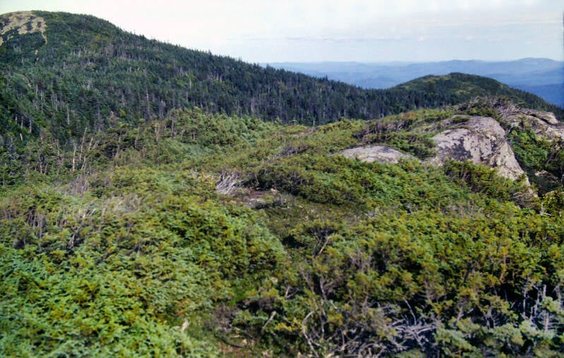
On the other hand, the entire span of ridge crest between the west and east peaks was rocky and open, with continual panoramic views.


I descended into a low sag and climbed over smooth, vertical rock ledges to the east peak.
Still September 13, 1983. Still Chapter 22.
Goose Eye was the scenic highlight of a memorably scenic day of hiking. The ensuing mile-and-a-quarter to the north peak of the mountain were mostly above tree line along an open, boggy ridge so characteristic of the crest of the Mahoosucs.


After another precipitous descent from East Peak, the Appalachian Trail traversed open rocks, scrubby peat moss bogs, and a couple of shallow, wooded canyons before making an easy, gradual ascent along the ridge to North Peak. Thanks, I needed that.
I did not need the final steep descent of the day, climbing down off of that open, rocky summit into a wooded col, but on the floor of that col was Full Goose Shelter, my home for tonight.


It was 6:45. I had pushed my exhausted, out-of-shape body over a lot of major obstacles and had accomplished the mileage goal I set for myself the previous night. Hopefully at not too high a cost.
A loud, fearless mouse dropped by the shelter that night. His constant chattering and scurrying around woke me up many times.
End of September 13, 1983. Still Chapter 22.
September 14, 1983, I did not hit the trail until almost 9:00. To make my next trail town before supplies ran out, I needed a fifteen-mile day, and I had Mahoosuc Notch and Mahoosuc Arm with which to contend this morning. As I was leaving the shelter, I was already in a big hole.
The night had been wintry, topping even Monday night for cold. September 14 was a perfect backpacking day: about fifty degrees and sunny, with another invigorating breeze.


The hike began with a steep but short climb up out of the col to the south peak of Fulling Mill Mountain. The Appalachian Trail descended gradually along the scrubby crest, turned left, and dived precipitously off of the ridge down into Mahoosuc Notch, which is famed as the most difficult mile of the entire trail. The descent into the notch was no picnic, either. I slipped several times on the smooth rocks as I made my way along, and my watch died.
That was extremely unfortunate, because Stratton is yet a few days ahead of me. A man like myself, whose tendency is towards late starts and down-to-the-wire finishes should not be without a watch hiking through the short days of mid-September in Maine.
I survived that rough descent only to face the toughest mile on the Appalachian Trail. The passage through Mahoosuc Notch truly lived up to that reputation. The notch was a deep, extremely narrow defile sandwiched between the towering cliffs of Fulling Mill Mountain and Mahoosuc Arm. Over the millennia, the floor of the notch had become the final resting place for every huge boulder which had broken away from those precipices. The trail wound over, around, and occasionally under that chaotic jumble of rocks. To make matters more interesting, those rocks were covered with a tenacious growth of gnarled conifers and dripping moss. It is probably the most deranged section of backpacking trail in the world, but its weird alien landscape was so striking I would not have missed it for anything.
I took my time and eventually made it through that long mile. On one occasion, I attempted to climb over some gigantic boulders rather than remove my backpack and drag it behind me through one of the narrow, twisting slab caves. I found myself at the top of a sheer fifteen-foot drop and was forced to backtrack and traverse the cave, anyway. From that point onward, I stuck to the trail.
Still September 14, 1983. Still Chapter 22.


My legs were a little rubbery when I emerged from the notch, and the climb up Mahoosuc Arm finished them off. This was the stuff of which backpacking legends are made.
The one-and-a-half-mile ascent bolted straight up old rockslides and smooth ledges. The footway was composed basically of loose rocks and exposed tree roots.
I was literally staggering by the time I scaled the final vertical rock face to the summit. There were marvelous panoramic views from up there, but what a price!


In no time, the views overcame the frustration. It was beautiful up there.
Still September 14, 1983. Still Chapter 22.
If I had it all to do over, I would have taken a half-hour meal break at the bottom of the notch, just before the climb. My pigheadedness about overcoming my late start and not stopping left me a quivering mass of exhausted muscles.
Still September 14, 1983. Still Chapter 22.


After all of this drama came a reasonably sane descent to Speck Pond, a very high beaver pond nestled along the ridge crest between Mahoosuc Arm and a spur of Old Speck Mountain. An attractive shelter sat beside its shore. A note at that shelter informed me that Frye Notch Shelter, which I had been hoping to reach tonight, was still under construction and presently lacked a roof. I was not going to make it there, anyway. I did get my watch to work again, at least until I reached the next trail town.
I began another steep climb up the ridge to Old Speck, dragging myself over some exceptionally excruciating, sheer ledges near the top. They completed the hatchet job on my legs.
Old Speck was the highest peak of the Mahoosucs at 4170 feet. There was a loooong descent to Grafton Notch, where the Appalachian Trail crossed Maine 26, the end of the Mahoosuc Range, and thus the end of the White Mountains.


Grafton Notch Lean-to was a half-mile past the road crossing, near a cascading stream about five minutes' walk off of the Appalachian Trail. I only covered about ten miles that day. Time to come up with another plan for my next resupply.
This brings us to the end of September 14, 1983. Still Chapter 22.
I got an early start September 15, 1983. The previous night was a memorably cold one. I had no choice but to get up get up and get moving at 5:30. It was still dark, so I went through my morning routine by the light of a candle and a flashlight. It was tough to psyche myself into removing my wool sweater, hat, and long pants when I set out in the cold, brittle sunlight of 7:00 a.m. I find that hiking in shorts adds about two extra miles to my day compared to hiking in long pants, and I needed every mile I could manage in order to reach Stratton before the food runs out.
My first view of the day overlooked a massive frozen river of fog in the lower valleys, similar to one I saw on a North Carolina morning an Appalachian Trail lifetime ago. But this time I thought to take out my camera.


The trail up to Baldpate's west peak warmed me up with long, insanely steep and eroded ascents. I no longer felt cold while hiking, but I didn't linger at the lookouts long.
The west peak rewarded me for my efforts, these two views among others: the frozen river of fog above and this fine view of Baldpate's main summit left.
My enthusiasm for the views was only slightly tempered by the fact that I would have to descend hundreds of feet into this sag between the two peaks and then climb to the higher east peak.
Looking back at the west peak from the sag.
Still September 15, 1983. Still Chapter 22.


A closer look at some of the plants that grow on the tundra-like open stretches of Baldpate. The Mahoosucs were very similar.
When I finally attained the west peak summit, I had checked my watch and discovered that it was almost 9:00. I had consumed two hours in hiking two-and-a-half miles. At the rate I had been covering ground for the past couple of days, Katahdin was beginning to once again achieve the status of fairy tale.
Looking back southwest over a shoulder of Baldpate's west peak to Old Speck, towering above Grafton Notch. I could see the top half of the previous day's long descent to the notch.
Still September 15, 1983. Still Chapter 22.

I'm still not done. More AT pics here.