My 1983 Appalachian Trail Hike in Photos
I wrote a ton in words in my journal as I hiked the Appalachian Trail. I also shot a ton of Kodachrome slides in that pre-digital age. I've scanned all my old AT slides and posted them with short text blurbs connecting them to their parts of the story. I'd never tried to connect all these slides with all these words before. It helped me remember details of that long-ago hike in new ways. These pages are a chronological visual journal of the hike. Probably one of the oldest thru-hikes on the Internet to get one.
More pics from my 1983 Appalachian Trail hike. Table of Contents is here.
Compton Gap, VA - Blue Mountain, PA
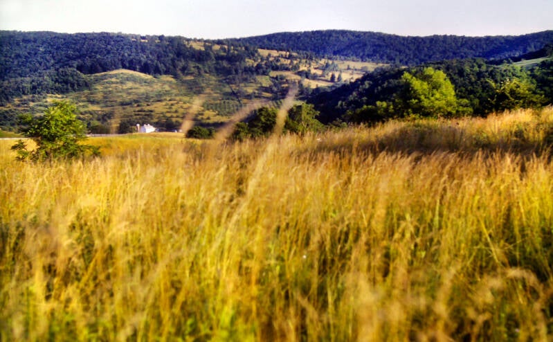
July 8, 1983. Chapter 11 of my story. My first three miles completed the descent from the Blue Ridge to the Appalachian Trail crossing of US Highway 522 in the valley below. Just before the road, I passed through an area which had been dubbed "The Tick Farm" by AT hikers. It consisted of about a half-mile of very tall grass that was simply crawling with the little mothers. I was lucky -- I only found about fifteen or twenty on me. I stopped once every minute to check until I had cleared the area, finding two or three ticks clinging to my socks each time.
The trail was easy between Shenandoah and Harpers Ferry, West Virginia. July 8 had even lower humidity than July 7, but after that the steam crept back in a bit more each day. I hiked 13 miles July 8 and finished for the day before 2:30, with a long stop in Linden, Virginia for resupply and a cold Coke and ice cream snack in the relentless July heat. I knocked off another 14 miles on July 9 and finished by 4:00, with a long stop in Paris at a nice diner. No, the one in Virginia. More than 6 miles were a single roadwalk. I covered 16 miles on July 10 and finished before 3:00. Behind that night's shelter, a side trail descended gently a tenth-of-a-mile to a little grocery store in Keys Gap. I had by far my biggest meal at any shelter on the AT that night. Northern Virginia was flying by in a haze of heat, roadwalks and solid food.
On July 11, after four miles on the Appalachian Trail, I reached the junction with the Loudon Heights Trail, which descended steeply off of the west side of the ridge into West Virginia. I had entered Virginia on June 7. As a result of the strange crawl of Time along the AT, that felt like a lifetime ago.
From Chapter 11 of my book, "A Backpacker in Paris".


I turned onto this path, which is part of the blue-blazed alternate route through Harpers Ferry, West Virginia. Virginia was now history, bringing us to the end of Chapter 11. I arrived at the headquarters of the Appalachian Trail Conference in Harpers Ferry at 10:30, checked in with them, stopped at the Post Office for my supply package, and got a room for the night at the Hilltop House.
July 12, 1983. Chapter 12 of my story. July in the mid-Atlantic states is miserable backpacking weather, and I needed to get back out into it before I grew too accustomed to comfort.
By noon, I was hoofing down the long, steep incline of Washington Street towards the Potomac waterfront.
I climbed a short flight of wooden steps up to the B&O railroad bridge over the Potomac. On the Maryland side of the river (five states down, nine to go), I crossed the remains of the old Chesapeake and Ohio barge canal.
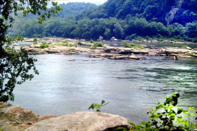

The railroad bridge over which I had crossed the Potomac was the unofficial section of the AT's Harpers Ferry side trail -- unofficial because the Baltimore and Ohio Railroad posts the walkway against trespassing in order to absolve themselves from legal responsibility in the event of a pedestrian accident. Having owned the deed to this railroad through many games of Monopoly, I felt entitled to bend the rules a bit.
The barge canal was a main artery of trade between Washington, D.C. and the interior for a time after its construction in the mid-1800's. Badly damaged during a Potomac River flood in 1924, it was never reopened. Today, the National Park Service administers 185 miles of the route as a linear National Historic Park. Much of the canal itself has been filled in, but its towpath still exists and has been made into a walking and bicycling path.
The old towpath was wide and flat and lined with tall shade trees whose intertwined branches formed a solid green canopy high overhead. That roof provided a valuable break from the relentless July sun and probably kept the air temperature beneath several degrees cooler. I turned onto the towpath and followed it east. Eventually, I passed the highway bridge, and the Appalachian Trail joined the towpath for a while. I was once again following its white paint blazes.
I had been informed by southbound hikers that the shelters in Maryland are all armpits. While on the canal path, I passed Weverton Shelter. The sight of that shelter made me glad that I would only be in Maryland for two nights. Directly adjacent to the towpath and easily accessible from a nearby road, it looked like it had been receiving heavy use from the local kids as a party spot. It was dirty and in a state of imminent collapse, with garbage strewn everywhere. If that was any indication of what is to come, my tent will come in very handy for a while.
From northern Virginia to western Connecticut, the Appalachian Trail runs very close to the western fringe of the developing megalopolis which stretches from Washington to Boston. Although it avoids the dense concentrations of humanity, the steady suburban flight of the previous twenty years definitely impacts this portion of the trail. A lot of people now live very close to the AT, and the old shelters which were built on or near roads during an era when these areas were the boondocks are now easily accessible to a considerable population. Vandalism and simple carelessness have led to the destruction or removal of many shelters and the degradation of many that remain. The results speak for themselves.
Not far past the shelter, the Appalachian Trail left the canal path, crossed the B&0 Railroad tracks, passed under US 340, and began the ascent of South Mountain. Sill July 12, 1983. Still Chapter 12.


South Mountain is the long ridge which I would be following throughout Maryland and into southern Pennsylvania. The views from Weverton Cliffs of the Potomac and the Virginia Blue Ridge beyond were impressive. My vantage point also made it painfully obvious just how humid it was. I could see steam hanging lifeless in the air like the inside of a sauna. Still, I was mighty happy to have that climb behind me, and the view perked me up a bit.
That night, I spread my sleeping bag on top of one of the picnic tables in Gathland State Park. A famous (in thru-hiker lore) Coke machine right on the Appalachian Trail in the park was my next stop.
On July 13, I hardly broke a sweat all day. The thermometer never rose above the lower eighties, and the humidity dropped like a stone as the morning progressed. At some otherwise insignificant spot along the trail between Crampton Gap and Lambs Knoll, the highest point on the AT in southern Maryland (1772 feet), I passed the 1000-mile mark on my thru-hike. One thousand miles.

I spent more than a month grinding through the massive Virginia chunk of the AT, but, in spite of my short day July 12 (less than ten miles), I left West Virginia behind and was only thirty-one miles from Pennsylvania. Maryland was a great morale booster.
On the morning of July 13, 1983 I was on the trail by 6:45. I had lunch at Washington Monument State Park, topped off with two Cokes purchased at yet another machine right on the Appalachian Trail. At the summit of Monument Knob in the park was a thirty-foot-tall observatory dedicated in 1827 as a monument to the father of our country and. It was rather odd-looking: a bottle-shaped stone tower. I took a walk to the top after lunch. The stale smoke and steam had moved off out over the Atlantic, leaving just the normal light haze of a July afternoon and sweeping panoramic views of a series of narrow parallel ridges and valleys.
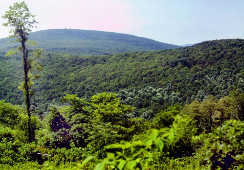
The Appalachian Trail traversed some gently rolling terrain along the ridgeline after the monument. With the exception of a very few viewpoints over the trees (next few pics), walking the flat, densely-wooded crest of South Mountain is indistinguishable from basic woodland hiking.
After three miles of this, the AT broke out of the forest, crossed a road, passed through a narrow right-of-way between two houses, and crossed over Interstate-70 on a concrete footbridge. That was different. Through the wire fencing on either side I could see streams of heavy traffic roaring past just below.


After weeks of slow crawl through southern forests and small villages, that flying crush of steel and chrome seemed like another universe.
The Cumberland Valley in Maryland is one of the valleys that make up the Great Appalachian Valley, running from Alabama to Canada.
Like the Virginia valleys: Shenandoah, James River, New River, etc. the AT had paralleled, the Cumberland was mostly rural with developing urban and suburban areas. But there was a lot more development in general. My next several hundred miles were going to be brushing against or traveling through the western edge of the Washington - Boston megalopolis. Hiking through Maryland, I was in it.


On the other side of I-70, the stiff climb up Pine Knob was a harbinger of things to come. I had been told, and I could see for myself from scanning the elevation profiles on my map, that the AT becomes much more rugged in the northern half of Maryland. Yes, I was already past the halfway point of the state.
I stopped at Pine Knob Shelter to get water.
Still Chapter 12, "One Thousand Miles". Still June 13, 1983.
It was another real dump -- filthy, decrepit, and generally falling apart. Chunks were missing from the walls. Past the shelter, the arduous climb continued, now on a badly eroded old woods road covered with rocks.
Once I had reached the ridge crest the footway became much easier, following wide old grassy roads across a broad, flat plateau.


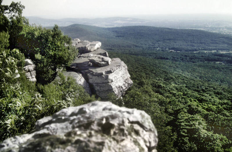
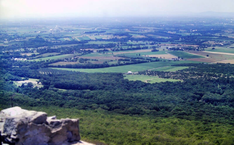
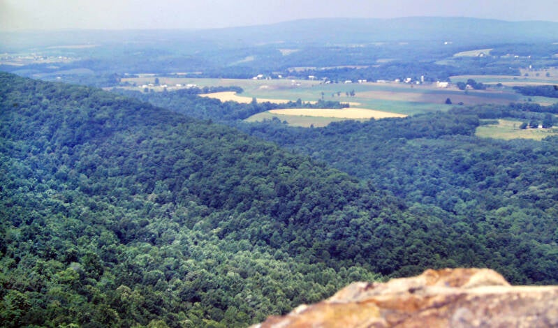
The views from Annapolis Rock and Black Rock along the western rim were the best in Maryland and blew away everything since Hogback Mountain and Mount Marshall in Shenandoah National Park.
Above each of these massive cliffs, hawks turned lazy circles in the afternoon sun, while below me others soared over a vast, green farming valley stretched out towards the blurry gray line of the Alleghenies in the misty distance.
I spent a great deal of time at each spot, feeling lucky to be there on one of the rare clear days this summer.
Less than a mile past Black Rock's cliffs, I came to a junction with a side trail leading down the flank of the mountain a bit, past the ruins of an old hotel to a beautiful, cold spring which gushed out of a pipe just below. I decided to make my dinner there, fill up my water bottles, and find a good place to camp.

On the AT, time usually crawls, but sometimes it flies. Things were beginning to break incredibly fast this stretch. On Monday I finally polished off Virginia. Tuesday took care of West Virginia. This day, Wednesday, I had passed the 1000-mile mark. Tomorrow I would enter Pennsylvania. No big milestones were on tap for Friday, but on Saturday I would cross the halfway point of the entire Appalachian Trail.
Still July 13, 1983. Still Chapter 12.
It definitely pays to get in as much of your mileage as you can while it is still relatively cool when you are backpacking in July. I did not get out on the trail July 14 until 7:15. I followed some seriously rocky trail this day. I was less than a hundred miles from the infamous rocks of central and eastern Pennsylvania, but their cousins had already begun to appear here and there along the Appalachian Trail in Maryland.

Thursday, July 14, 1983 was a 21-mile hiking day for me, the first 15 of which were in Maryland. The previous day's cool spell had ended after one day in a row. It was sweltering in the nineties once again and the humidity was soaring.
I nursed a few ounces of blood-warm water along the steep, rocky climb up Buzzards Knob. Fortunately, the spring I found near the summit was cold and tasty. I chugged water until I almost threw up to prepare myself for the seven-mile stretch of waterless trail which was on tap.
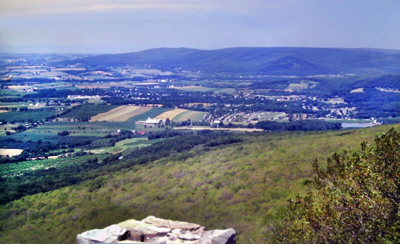
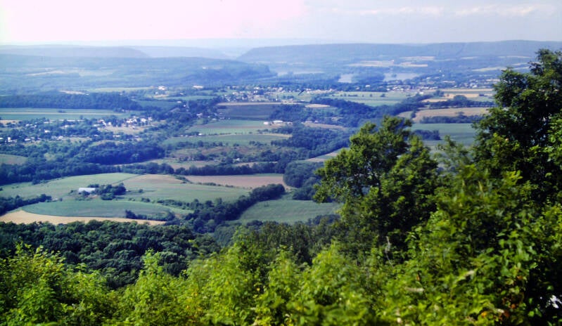
At the end of this stretch, High Rock had excellent views north and west of the Cumberland Valley in Pennsylvania and a takeoff platform for hang gliders.
Pen Mar Park far below was packed with summer picknickers. A nice lady gave me a couple of cold sodas when it turned out there was nowhere to buy them in the park. I soon left the park, crossing the state line into Pennsylvania a couple of minutes later, bringing us to the end of Chapter 12.
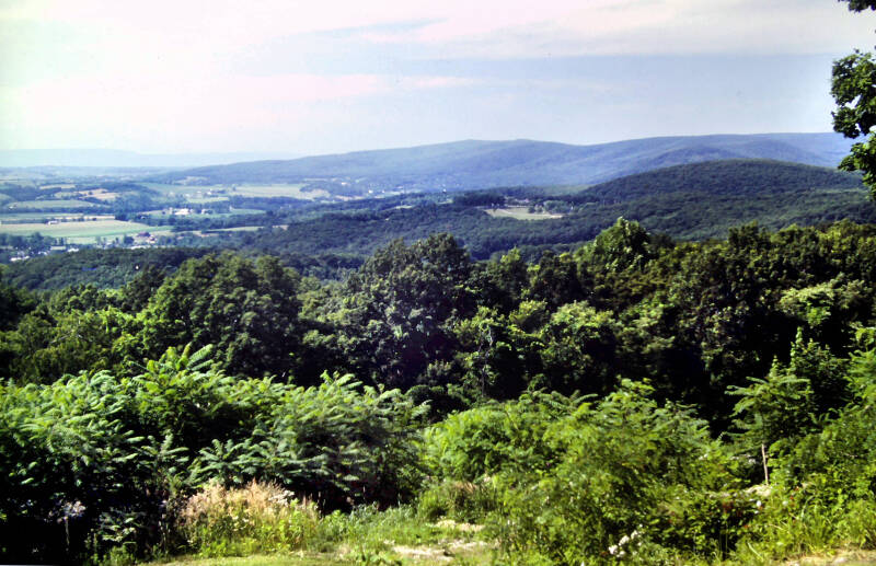
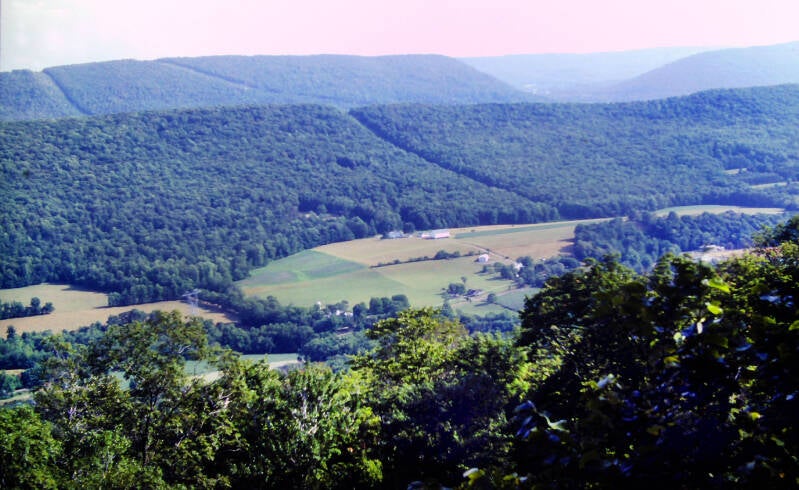
I shot no pics in Pen Mar or in this part of Pennsylvania, so here's a couple more from on and around High Point. As Chapter 13 begins, I continued along South Mountain six more sweltering miles to the second Pennsylvania shelter. Both shelters were near roads. Mackie Run was trashed, but Antietam Shelter was in excellent condition. I spent the night there, the sultriest yet on this hike. At 9:30 I was lying atop my sleeping bag in my underwear, sweating bullets. I knew then that July 15 would be a memorably hot one. Sure enough, it was already around eighty when I hit the trail at 7:15.
Early that day I took a side trail to Chimney Rocks. The viewpoint looked promising, but most of the views were invisible through air that was three parts steam and two parts smoke. So, here's another view from High Point. I returned to the AT and resumed hiking a 20-mile day under the dreary whitewashed sky. For the first time since Shenandoah, the trail attained an elevation of more than 2000 feet near Snowy Mountain's wooded summit. I would not see that altitude again until Connecticut.

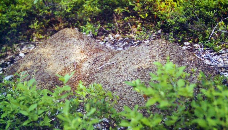
The first six miles July 16 were similar to the last few miles of the day before. The Appalachian Trail followed the long, relatively flat top of South Mountain, paralleling a gravel track which ran for miles along the ridge crest. Mounds of loose dirt almost as tall as a man bordered the trail at frequent intervals. They looked soft and inviting in the wearying heat, at least until I noticed the swarms of ants running in and out. They must have required countless generations of ant labor.
The AT crossed a number of dirt roads that ran east-to-west across the ridge. My 20- and 21-mile days July 15 and 16 each led me by a popular swimming area packed with people. It was extremely strange at that point to walk among those masses. Because I am a philosopher poet, the bikinis helped me overcome my recent aversion to crowds for a while. July 15's was a huge swimming pool - with a snack bar! On July 16 the AT followed a lake's crowded sandy beach for a while. I spent the evening of July 16 in my tent in a commercial campground with groceries, hot showers and laundry. That day I had crossed the halfway point of the Appalachian Trail. Still Chapter 13.

If you think southern Pennsylvania, following the long flat crest of South Mountain beside the Cumberland Valley looks a lot like most of Mayland, following the long flat crest of South Mountain beside the Cumberland Valley, well, yeah. South Mountain is the northeastern extension of the Blue Ridge. At the trail's Cumberland Valley crossing, South Mountain and Piney Mountain peter out, and the Blue Ridge is no more. In 1983, this resulted in the Cumberland Valley roadwalk, more than 15 miles of mostly paved roads.
It began with several miles of tough, rocky trail on July 17, 1983, on a day that would push 100 degrees. I broke out onto the roadwalk at about 10:30, and the real death march began. Temperatures were now in the nineties and humidity hung in the air so thickly that it resembled smoke. How can I describe the Cumberland Valley roadwalk this afternoon? The AT passed through a flat country of old farm fields and newer subdivisions. There were virtually no shade trees along much of the route. The humidity was like death. The tar was semiliquid on the roads, grabbing at the soles of my boots and releasing them only reluctantly as I trudged along. The whole valley around me was twitching spasmodically on shimmering heat waves. The thick, stagnant haze seemed to magnify rather than block the glare. One vast sun appeared to be beating down from every point of the white dome of the sky.
Eventually I made it up a steep jeep road to a shelter on Blue Mountain less than twelve miles from my next trail town, Duncannon, PA. I had hot bathwater in my canteen most of the way across, but this was supplemented on two occasions, one early one late, by the legendary kindness of the Cumberland Valley residents. A heavily air-conditioned restaurant in the truck stop on US 11 near the interstate about halfway across also helped greatly. I was now down to 175 -- fifty pounds lighter than when I began this hike ten weeks earlier, and fifteen or twenty pounds less than my ideal weight.


The heat and humidity brewed up a monster thunderstorm that night -- which thankfully struck while I was in the shelter. It did not cool things off any. July 18, 1983 was another steamy day in the middle hundreds, but at least the night's moisture helped keep the dust down as I walked. The Appalachian Trail descended off of Blue Mountain, climbed over a ridge of its foothills known as Little Mountain, and followed a dirt road for a half-mile into a narrow valley sandwiched between the long, parallel ridges of Blue Mountain and Cove Mountain. It crossed Pennsylvania 850, a small country highway, and followed gravel and woods roads for about a mile through thick forests. A climb up Cove Mountain was short, but sadistically steep.
Along the four-mile crest of Cove Mountain, I finally met the famous Pennsylvania rocks, which did a number on the soles of my feet. Just prior to my final descent from Cove Mountain, I found a great viewpoint though the haze over the Susquehanna River Valley at Hawk Rock. The trail followed paved roads directly into downtown Duncannon. I hit the Post Office to pick up my mail and supply package and walked over to the Doyle Hotel to get a room for the night. July 18 and Chapter 13 were now over.


July 19, 1983. Chapter 14: "On the Rocks". I felt pretty good when I awoke in the hotel 8:00 that morning. I had not been sleeping well in the shelters during the heat wave. Outside my window, heat waves were already shimmering above the asphalt below. I went through my departure preparations with a marked lack of enthusiasm. It was 11:00 when I finally loaded my backpack, got dressed, and went downstairs.
The AT crossed two major rivers, the Juniata and the Susquehanna, on highway bridges along the roadwalk just past the town. The Susquehanna, in southern and central Pennsylvania, is a broad river with few bridges. The Clarks Ferry Bridge was almost a half-mile in length and packed with slow-moving automobiles belching more smoke and heat into the dead, sultry air. Reaching the hundred-degree mark was going to be a cinch again today, if we weren't there already.


On the eastern bank, I had to run across a busy four-lane highway, US 22. The Appalachian Trail paralleled the highway and the river for a quarter mile along a set of railroad tracks. My good feeling was rapidly evaporating. The subsequent climb up Peters Mountain finished the job.
I arrived at Earl Shaffer Shelter at about 6:30. It had taken me six-and-a-half hours to hike ten-and-a-half miles. The air was equal parts steam and summer smog, possibly my dreariest sunny day on the AT.
My schedule to Delaware Water Gap looked to be in trouble. The record heat was beginning to grind me down. The thermometer had failed to reach the mid-nineties once since Shenandoah and had been topping one hundred for almost a week. I had been tapping into the reserves constantly lately, and the benefits of those few easy days in northern Virginia had been used up.
Still July 19, 1983. Chapter 14.

I left the shelter July 20's morning at 7:00 -- not a terribly early start. The remainder of the trail over Peters Mountain was much like the last few miles of hiking the previous day. The rocks continued to be tolerable. The descent from Peters Mountain, in its steepness, was a replay of yesterday's climb, but it was shorter and thus was over more quickly. I stopped at an excellent spring a half-mile from the bottom.
I did not know it at the time, but that turned out to be the last good water on the Appalachian Trail for almost twelve miles. Fortunately, out of habit, I "cameled up." I drank three pints of water on the spot to saturate my tissues and carried another three pints with me in my canteen. The ensuing climb up Stony Mountain was a surprising throwback to the good old days of nicely graded trails down south.


The old woods road that the AT followed took more than three miles to climb about 1100 feet. My map showed a spring near the summit alongside a spot where a fire tower once stood. The spring was dry.
I did the final five miles of the day to the shelter in ninety minutes, barely winning a race with the massive thundershower which I could see approaching. Thanks to the impetus of that storm, I arrived at the shelter before 4:00 and had the day's hike done with early for the first time in a very long while.
Still July 20, 1983. Still in Chapter 14.
Several local short-term backpackers were staying at the shelter. One had a radio. The weather report called for no relief in sight from the record heat and humidity, and scattered afternoon thundershowers. That last part was especially bad news for me, because I was going to be compelled to camp out the next night. The closest shelter was thirty-two miles away.

I had hiked seventeen miles July 20 in eight-and-a-half hours, with three long rest stops along the way. As it was only my second day out since resupplying in Duncannon, I was carrying an exceptionally heavy backpack. The rocks did not seem to be slowing me down all that much... so far. I was feeling a little more optimistic about my chances of staying on schedule and covering the remaining 116 miles to Delaware Water Gap in five-and-a-half days.
Still Chapter 14.
At a point about a mile into my hike July 21, 1983, I was officially exactly one thousand Appalachian Trail miles from Mount Katahdin. After my next step, the remaining AT miles would now be counted with three digits. As usual, this significant milestone happened at a pleasant spot otherwise indistinguishable from 99% of the trail. Not even at this modest viewpoint.


I had left the shelter at 6:45. The AT was very easy walking along old woods roads. Then came a prelude of things to come. The trail up and over Second Mountain was almost completely obliterated by the growth of small trees. Their branches overlapped each other across the trail in many places. The storm I had barely avoided the night before soaked me second-hand today, as I bulled my own path through the wet intertwined branches. The descent from Second Mountain was on wide woods roads like this, a fact I really appreciated after that overgrown trail. This was followed by a four-mile walk on paved roads. About a mile into the roadwalk, I came to a small store named Ron's Grocery.
The people who ran the store were very congenial and made a special effort to cater to hikers. They carried all sorts of groceries appropriate for backpacking and had a policy of accepting and holding mail for hikers. They even kept a register notebook at the store for us. I ate a nourishing second breakfast consisting of a coke, some cookies, and a pint of ice cream. I bought a box of Pop-Tarts as I hit the road. My munchies, as always, were running a little low.
Still July 21, 1983. Still in Chapter 14.
The rest of the roadwalk sailed by. Near its end, I came through Swatara Gap, crossing a creek on an interesting old iron bridge from the late 1800s, then an old barge canal. The AT passed under Interstate 81 just before leaving the road and climbing Blue Mountain. I was humming along on an intense sugar and caffeine rush.


Then I met Blue Mountain. After a long, steep climb, I was greeted on the ridge crest by endless ranks of shoulder-high weeds which completely engulfed the trail. Many brandished long, sharp thorns.
This grassy woods road was just moderately overgrown. It should be mentioned that it is very hard to keep grassy and weedy trails clear during a time of year when it is still peak growing season, and every day outdoor people walk outside into the blistering heat and decide it's a beach day. Other times of the year foot traffic does a lot of the work.
Within minutes, I was bleeding from dozens of scratches on my unprotected arms and legs. That was a fairly constant experience for the rest of the day. At one point, the trail clung to the edge of a steep slope with a sharp drop only inches away. In order to stay on that narrow shelf, I had to wade directly through the briar bushes that projected out over it. I guess I could have worn long pants and a long-sleeved shirt. That was an unappealing thought. It was another blistering day in the high nineties.
The rocks were the worst that I had yet seen -- little rocks, big rocks, loose rocks, sharp rocks. I have short legs for my height and a low center of gravity. I tend not to lift my feet very high as I step; when I am walking fast, I have a habit of kicking my feet forward. This is not the recommended walking style for a path which is studded with half-buried rocks, particularly when you begin to tire and grow careless.
Still July 21, 1983. Still in Chapter 14.


In both the pic above and this one, the Appalachian Trail goes right through the middle of the pic, bottom to top. Not to be a broken record, but I am also not blaming the trail clubs for this. Look into the woods on either side of the trail and the same rocks are everywhere. There is no alternative route.
Blue Mountain also turned out to be home to swarms of gnats, flies, and mosquitoes. Gnats maintained a constant assault, biting me and flying into my eyes as I hiked. Flies hovered around me all day, crawling all over me in droves every time I tried to sit down. I was breakfast, lunch, dinner, and between meal snacks for the mosquitoes. I should have used insect repellent. It would have helped a little, but it never occurred to me. My mind was somewhere else all day, trying to find what pop psychologists call my "happy place." I didn't know where that is exactly, but I was fairly certain you can't get there from here -- Blue Mountain, Pennsylvania in the heart of high summer.
I arrived at Hertlein Campsite at about 6:30. I had just enough time to pitch my tent before a thundershower struck. The best thing I could say about this day's hike is that I was twenty-one miles closer to Delaware Water Gap, where the Appalachian Trail leaves Blue Mountain.
I was also eighteen miles from the village of Port Clinton, where I could get a room for the night and where some letters from home should be awaiting me at the Post Office. Perhaps tomorrow would be a better day.
End of July 21, 1983. Still in Chapter 14.

I'm still not done. More AT pics here.